
Thank you for supporting this site ❤️
Make a donation
Make a donation
Normandy topographic map
Click on the map to display elevation.
Thank you for supporting this site ❤️
Make a donation
Make a donation
About this map
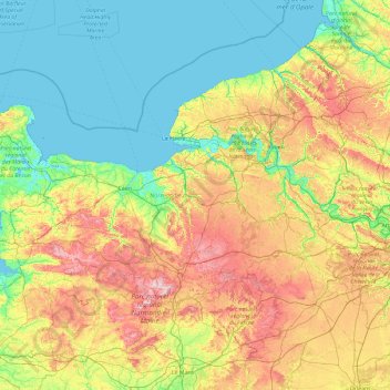
Name: Normandy topographic map, elevation, terrain.
Location: Normandy, Metropolitan France, France (48.17939 -1.95506 50.07581 1.80286)
Average elevation: 98 m
Minimum elevation: -2 m
Maximum elevation: 408 m
Thank you for supporting this site ❤️
Make a donation
Make a donation
Other topographic maps
Click on a map to view its topography, its elevation and its terrain.
Thank you for supporting this site ❤️
Make a donation
Make a donation
Thank you for supporting this site ❤️
Make a donation
Make a donation
Thank you for supporting this site ❤️
Make a donation
Make a donation