
Thank you for supporting this site ❤️
Make a donation
Make a donation
Knappville topographic map
Click on the map to display elevation.
Thank you for supporting this site ❤️
Make a donation
Make a donation
About this map
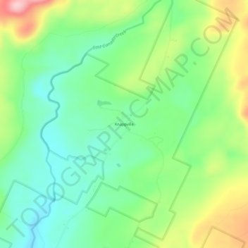
Name: Knappville topographic map, elevation, terrain.
Average elevation: 444 m
Minimum elevation: 372 m
Maximum elevation: 576 m
Thank you for supporting this site ❤️
Make a donation
Make a donation
Other topographic maps
Click on a map to view its topography, its elevation and its terrain.
Great Sacandaga Lake
United States > New York > Fulton County > Town of Hadley
Average elevation: 370 m
Thank you for supporting this site ❤️
Make a donation
Make a donation
Thank you for supporting this site ❤️
Make a donation
Make a donation
West Caroga Lake
United States > New York > Fulton County > Town of Caroga > Caroga Lake
Average elevation: 464 m