
Thank you for supporting this site ❤️
Make a donation
Make a donation
Wangunharja topographic map
Click on the map to display elevation.
Thank you for supporting this site ❤️
Make a donation
Make a donation
About this map
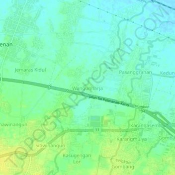
Name: Wangunharja topographic map, elevation, terrain.
Location: Wangunharja, Cirebon, West Java, Java, 45154, Indonesia (-6.71200 108.44751 -6.67200 108.48751)
Average elevation: 16 m
Minimum elevation: 8 m
Maximum elevation: 27 m
Thank you for supporting this site ❤️
Make a donation
Make a donation