
Thank you for supporting this site ❤️
Make a donation
Make a donation
Phyang topographic map
Click on the map to display elevation.
Thank you for supporting this site ❤️
Make a donation
Make a donation
About this map
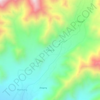
Name: Phyang topographic map, elevation, terrain.
Location: Phyang, Leh Tehsil, Leh district, Ladakh, 194101, India (34.17093 77.47409 34.21093 77.51409)
Average elevation: 3,742 m
Minimum elevation: 3,407 m
Maximum elevation: 4,400 m
Thank you for supporting this site ❤️
Make a donation
Make a donation
Other topographic maps
Click on a map to view its topography, its elevation and its terrain.
Indus
India > Ladakh > Leh Tehsil
In the uppermost, highest part of the Indus River basin there are relatively few genera and species: Diptychus, Ptychobarbus, Schizopyge, Schizopygopsis and Schizothorax snowtrout, Triplophysa loaches, and the catfish Glyptosternon reticulatum. Going downstream these are soon joined by the golden mahseer Tor…
Average elevation: 4,192 m