
Thank you for supporting this site ❤️
Make a donation
Make a donation
Illa Roja topographic map
Click on the map to display elevation.
Thank you for supporting this site ❤️
Make a donation
Make a donation
About this map
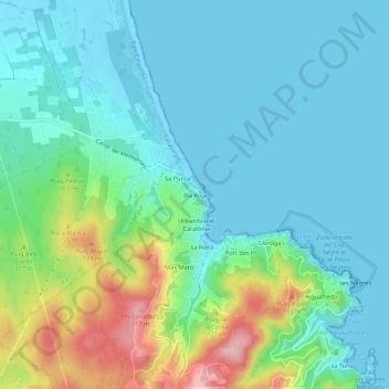
Name: Illa Roja topographic map, elevation, terrain.
Location: Illa Roja, Begur, Bajo Ampurdán, Gerona, Cataluña, 17213, España (41.95790 3.18879 41.99790 3.22879)
Average elevation: 49 m
Minimum elevation: -3 m
Maximum elevation: 211 m
Thank you for supporting this site ❤️
Make a donation
Make a donation
Other topographic maps
Click on a map to view its topography, its elevation and its terrain.