
Make a donation
Khan Tengri topographic map
Click on the map to display elevation.
Make a donation
Khan Tengri
Khan Tengri is a mountain of the Tian Shan mountain range in Central Asia. It is on the China—Kyrgyzstan—Kazakhstan tripoint, east of lake Issyk Kul. Its geologic elevation is 6,995 m (22,949 ft), but its glacial icecap rises to 7,010 m (22,999 ft). For this reason, in mountaineering circles, including for the Soviet Snow Leopard award criteria, it is considered a 7,000-metre peak.
Make a donation
About this map
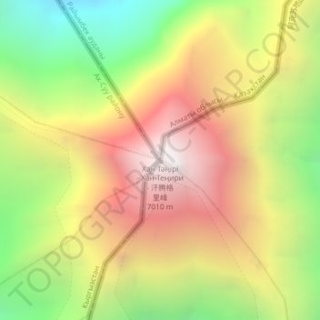
Name: Khan Tengri topographic map, elevation, terrain.
Location: Khan Tengri, Ak-Suu District, Issyk-Kul Region, Kyrgyzstan (42.21079 80.17435 42.21089 80.17445)
Average elevation: 5,894 m
Minimum elevation: 4,775 m
Maximum elevation: 6,978 m
Make a donation
Other topographic maps
Click on a map to view its topography, its elevation and its terrain.
Ala-Köl
Kyrgyzstan > Issyk-Kul Region > Ak-Suu District
Ala-Köl (Kyrgyz: Ала-Көл, also Алакөл, Russian: Ала-Куль, romanized: Ala-Kul) is a rock-dammed lake in the Terskey Alatau mountain range in the Ak-Suu District of the Issyk-Kul Region in Kyrgyzstan. It lies at an altitude of 3,532 m (11,588 ft). It is 2.8 km (1.7 mi) long and 600–700 m…
Average elevation: 3,703 m