
Make a donation
Welshpool topographic map
Click on the map to display elevation.
Make a donation
Welshpool
The Mermaid Inn, 28 High Street, was very probably an early 16th-century merchant's house, placed on a burgage plot between the High Street and Alfred Jones Court. The timber-framed building has long storehouse or wing to the rear. The frontage was remodelled c. 1890, by Frank H. Shayler, architect, of Shrewsbury. Early illustrations of the building show that prior to this it had a thatched roof and that the timbering was not exposed. There is a passage to side with heavy box-framing in square panels, with brick infill exposed in side elevation and in rear wing. The frontage was exposed by Shayler to show decorative timber work on the upper storey. An Inn by the 19th century when it was owned by a family named Sparrow.
Make a donation
About this map
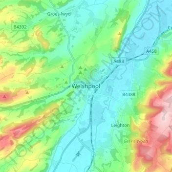
Name: Welshpool topographic map, elevation, terrain.
Location: Welshpool, Powys, Wales, SY21 7SD, United Kingdom (52.62007 -3.18742 52.70007 -3.10742)
Average elevation: 156 m
Minimum elevation: 63 m
Maximum elevation: 412 m
Make a donation
Other topographic maps
Click on a map to view its topography, its elevation and its terrain.
Brecon Beacons National Park
United Kingdom > Wales > Powys
Brecon Beacons National Park, officially named Bannau Brycheiniog National Park (Welsh pronunciation), is a national park in Wales. It is named after the Brecon Beacons (Welsh: Bannau Brycheiniog), the mountain range at its centre. The national park includes the highest mountain in South Wales, Pen y Fan,…
Average elevation: 270 m
Make a donation