
Make a donation
Monticello topographic map
Click on the map to display elevation.
Make a donation
Monticello
Monticello is located at the base of the Abajo Mountains, or the Blue Mountains, which are part of the Manti-La Sal National Forest. The elevation of Monticello is 7,069 feet (2,155 m). From Monticello, a tree formation on the Blue Mountains can be seen, which resembles a horse's head and neck, which can be seen from any point in town.
Make a donation
About this map
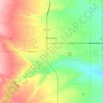
Name: Monticello topographic map, elevation, terrain.
Location: Monticello, San Juan County, Utah, United States (37.85117 -109.36881 37.88708 -109.31155)
Average elevation: 2,145 m
Minimum elevation: 2,049 m
Maximum elevation: 2,240 m
Make a donation
Other topographic maps
Click on a map to view its topography, its elevation and its terrain.
Colorado Plateau
United States > Utah > San Juan County
Younger igneous rocks form spectacular topographic features. The Henry Mountains, La Sal Range, and Abajo Mountains, ranges that dominate many views in southeastern Utah, are formed about igneous rocks that were intruded in the interval from 20 to 31 million years: some igneous intrusions in these mountains…
Average elevation: 1,512 m
Make a donation
Colorado Plateau
United States > Utah > San Juan County
Younger igneous rocks form spectacular topographic features. The Henry Mountains, La Sal Range, and Abajo Mountains, ranges that dominate many views in southeastern Utah, are formed about igneous rocks that were intruded in the interval from 20 to 31 million years: some igneous intrusions in these mountains…
Average elevation: 1,512 m