
Make a donation
Brambleton topographic map
Click on the map to display elevation.
Make a donation
About this map
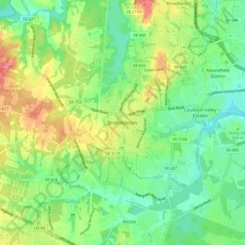
Name: Brambleton topographic map, elevation, terrain.
Location: Brambleton, Loudoun County, Virginia, 20107, United States (38.94421 -77.57672 39.02421 -77.49672)
Average elevation: 99 m
Minimum elevation: 69 m
Maximum elevation: 148 m
Make a donation
Other topographic maps
Click on a map to view its topography, its elevation and its terrain.
Leesburg
United States > Virginia > Loudoun County
Leesburg is located northeast of the center of Loudoun County at 39°7′N 77°33′W / 39.117°N 77.550°W / 39.117; -77.550 (39.109, −77.558), It is part of the northern Virginia Piedmont and sits at the base of the easternmost chain of the Blue Ridge Mountains, Catoctin Mountain. The town lies in…
Average elevation: 113 m
Sterling
United States > Virginia > Loudoun County
According to the USGS, Sterling has an average elevation of 289 feet (88 m) above sea level. The original center of Sterling is located at 39°00'22.4"N 77°25'43.0"W. Sterling is part of the Chesapeake Bay watershed, and Greater Sterling borders the Potomac River.
Average elevation: 97 m
Lucketts Community Center
United States > Virginia > Loudoun County > Lucketts
Average elevation: 101 m
Make a donation