
Thank you for supporting this site ❤️
Make a donation
Make a donation
La Ferté topographic map
Click on the map to display elevation.
Thank you for supporting this site ❤️
Make a donation
Make a donation
About this map
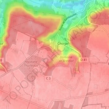
Name: La Ferté topographic map, elevation, terrain.
Average elevation: 155 m
Minimum elevation: 75 m
Maximum elevation: 181 m
Thank you for supporting this site ❤️
Make a donation
Make a donation
Other topographic maps
Click on a map to view its topography, its elevation and its terrain.
Château de Breteuil
France > Île-de-France > Yvelines > Choisel > Herbouvilliers
Average elevation: 163 m