
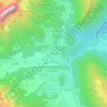
Ruthière topographic map
Interactive map
Click on the map to display elevation.
About this map
Name: Ruthière topographic map, elevation, terrain.
Average elevation: 1,132 m
Minimum elevation: 747 m
Maximum elevation: 2,078 m
Other topographic maps
Click on a map to view its topography, its elevation and its terrain.
Donnière
France > Auvergne-Rhône-Alpes > Isère > Chichilianne > Donnière
Donnière, Chichilianne, Grenoble, Isère, Auvergne-Rhône-Alpes, France métropolitaine, 38930, France
Average elevation: 1,268 m
Charbonnier
France > Auvergne-Rhône-Alpes > Isère > Chichilianne
Charbonnier, Chichilianne, Grenoble, Isère, Auvergne-Rhône-Alpes, France métropolitaine, 38930, France
Average elevation: 1,125 m
Mont Aiguille
France > Auvergne-Rhône-Alpes > Isère > Chichilianne
Mont Aiguille, Chichilianne, Grenoble, Isère, Auvergne-Rhône-Alpes, France métropolitaine, 38930, France
Average elevation: 1,395 m
Les Oches
France > Auvergne-Rhône-Alpes > Isère > Chichilianne
Les Oches, Chichilianne, Grenoble, Isère, Auvergne-Rhône-Alpes, France métropolitaine, 38930, France
Average elevation: 1,131 m
Richardière
France > Auvergne-Rhône-Alpes > Isère > Chichilianne
Richardière, Chichilianne, Grenoble, Isère, Auvergne-Rhône-Alpes, France métropolitaine, 38930, France
Average elevation: 1,304 m
Prarron
France > Auvergne-Rhône-Alpes > Isère > Chichilianne > Château-Vieux
Prarron, Château-Vieux, Chichilianne, Grenoble, Isère, Auvergne-Rhône-Alpes, France métropolitaine, 38930, France
Average elevation: 1,071 m