
Algeria topographic map
Interactive map
Click on the map to display elevation.
About this map
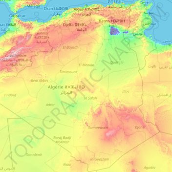
Name: Algeria topographic map, elevation, terrain.
Location: Algeria (18.96815 -8.66891 37.29621 11.99734)
Average elevation: 511 m
Minimum elevation: -31 m
Maximum elevation: 3,622 m
Other topographic maps
Click on a map to view its topography, its elevation and its terrain.
Assekrem
Algeria > Tamanrasset > de Tamanrasset District > Tamanghasset
Assekrem is a high plateau in the Hoggar Mountains of southern Algeria. Rising from the larger Atakor plateau, Assekrem is within Ahaggar National Park. The maximum altitude of the plateau is 2,726 metres (8,944 ft).
Average elevation: 2,537 m