
Thank you for supporting this site ❤️
Make a donation
Make a donation
Cime Scandaillière topographic map
Click on the map to display elevation.
Thank you for supporting this site ❤️
Make a donation
Make a donation
About this map
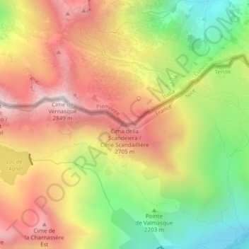
Name: Cime Scandaillière topographic map, elevation, terrain.
Average elevation: 2,356 m
Minimum elevation: 1,836 m
Maximum elevation: 2,831 m
Thank you for supporting this site ❤️
Make a donation
Make a donation
Other topographic maps
Click on a map to view its topography, its elevation and its terrain.
Fort Tabourde
France > Provence-Alpes-Côte d'Azur > Alpes-Maritimes > Tende
Average elevation: 1,673 m
Vallée des Merveilles
France > Provence-Alpes-Côte d'Azur > Alpes-Maritimes > Tende
Average elevation: 2,416 m
Lac de l'Agnel
France > Provence-Alpes-Côte d'Azur > Alpes-Maritimes > Tende
Average elevation: 2,510 m
Thank you for supporting this site ❤️
Make a donation
Make a donation
Refuge de Fontanalba
France > Provence-Alpes-Côte d'Azur > Alpes-Maritimes > Tende
Average elevation: 2,122 m