
Make a donation
Hasr topographic map
Click on the map to display elevation.
Make a donation
About this map
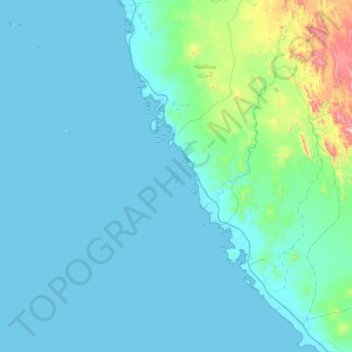
Name: Hasr topographic map, elevation, terrain.
Location: Hasr, Al Birk, Saudi Arabia (17.82750 41.21889 18.46750 41.85889)
Average elevation: 92 m
Minimum elevation: -1 m
Maximum elevation: 1,043 m
Make a donation
Other topographic maps
Click on a map to view its topography, its elevation and its terrain.
Make a donation
Al-Bahah Province
The region is divided by huge rocky steeps into two main sectors. To the west is a coastal plain, the Tihamah. To the east is the mountain range of al-As-Sarawat or the Sarat, with an elevation of 1,500 to 2,450 m (4,920 to 8,040 ft) above sea level.
Average elevation: 1,154 m
Make a donation
Make a donation
Make a donation
Make a donation
Makkah Region
Most of the central and eastern portions of the province are desert, with the Hejaz mountains, which vary in elevation from 600 meters to 2000 meters, separating the relatively flat Nafud desert and coastal plains. Agriculture takes place in the region's many wadis and oases, with the most commonly-grown crops…
Average elevation: 785 m
Make a donation
Make a donation