
Thank you for supporting this site ❤️
Make a donation
Make a donation
Masherbrum (K1) topographic map
Click on the map to display elevation.
Thank you for supporting this site ❤️
Make a donation
Make a donation
Masherbrum (K1)
Masherbrum (Urdu: مشہ بروم ; formerly known as K1) is a mountain located in the Ghanche District in the Gilgit Baltistan region of Pakistan. With an elevation of 7,821 metres (25,659 feet), it ranks as the 22nd highest mountain globally and the 9th highest in Pakistan. It holds the distinction of being the first mapped peak in the Karakoram mountain range during the Great Trigonometrical Survey, leading to its K-number designation as "K1".
Thank you for supporting this site ❤️
Make a donation
Make a donation
About this map
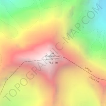
Name: Masherbrum (K1) topographic map, elevation, terrain.
Location: Masherbrum (K1), Gilgit-Baltistan, Pakistan (35.64333 76.30805 35.64343 76.30815)
Average elevation: 6,469 m
Minimum elevation: 4,912 m
Maximum elevation: 7,798 m
Thank you for supporting this site ❤️
Make a donation
Make a donation