
Thank you for supporting this site ❤️
Make a donation
Make a donation
Kastraki topographic map
Click on the map to display elevation.
Thank you for supporting this site ❤️
Make a donation
Make a donation
About this map
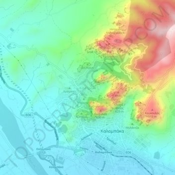
Name: Kastraki topographic map, elevation, terrain.
Average elevation: 330 m
Minimum elevation: 196 m
Maximum elevation: 674 m
Thank you for supporting this site ❤️
Make a donation
Make a donation
Other topographic maps
Click on a map to view its topography, its elevation and its terrain.
Meteora Municipality
Greece > Thessaly and Central Greece > Trikala Regional Unit
Average elevation: 860 m
Trikala Municipality
Greece > Thessaly and Central Greece > Trikala Regional Unit
Average elevation: 350 m