
Thank you for supporting this site ❤️
Make a donation
Make a donation
Corsica topographic map
Click on the map to display elevation.
Thank you for supporting this site ❤️
Make a donation
Make a donation
Corsica
According to the Köppen climate classification scheme, coastal regions are characterized by a hot-summer Mediterranean climate (Csa). Further inland, a warm-summer Mediterranean climate (Csb) is more common. At the highest elevation locations, small areas with a subarctic climate (Dsc, Dfc) and the rare Mediterranean climate can be found.
Thank you for supporting this site ❤️
Make a donation
Make a donation
About this map
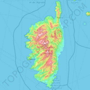
Name: Corsica topographic map, elevation, terrain.
Location: Corsica, Metropolitan France, France (41.33319 8.53472 43.02771 9.56001)
Average elevation: 139 m
Minimum elevation: -5 m
Maximum elevation: 2,546 m
Thank you for supporting this site ❤️
Make a donation
Make a donation
Other topographic maps
Click on a map to view its topography, its elevation and its terrain.
Thank you for supporting this site ❤️
Make a donation
Make a donation
Thank you for supporting this site ❤️
Make a donation
Make a donation
Thank you for supporting this site ❤️
Make a donation
Make a donation