
Cottonwood Point topographic map
Interactive map
Click on the map to display elevation.
About this map
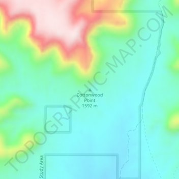
Name: Cottonwood Point topographic map, elevation, terrain.
Location: Cottonwood Point, Kane County, Utah, United States (37.02494 -112.62026 37.02504 -112.62016)
Average elevation: 1,641 m
Minimum elevation: 1,527 m
Maximum elevation: 1,931 m
Other topographic maps
Click on a map to view its topography, its elevation and its terrain.
Long Valley Junction
United States > Utah > Kane County
Long Valley Junction, Kane County, Utah, 84710, United States
Average elevation: 2,295 m
Navajo Lake
United States > Utah > Kane County > Navajo Lake Lodge
Navajo Lake, Navajo Lake Lodge, Kane County, Utah, United States
Average elevation: 2,851 m
Coyote Gulch
United States > Utah > Kane County
Coyote Gulch, Kane County, Utah, United States
Average elevation: 1,361 m
Lone Rock Beach
United States > Utah > Kane County
Lone Rock Beach, Kane County, Utah, United States
Average elevation: 1,134 m
Spooky Gulch
United States > Utah > Kane County
Spooky Gulch, Kane County, Utah, United States
Average elevation: 1,472 m