
Thank you for supporting this site ❤️
Make a donation
Make a donation
Le Pin topographic map
Click on the map to display elevation.
Thank you for supporting this site ❤️
Make a donation
Make a donation
About this map
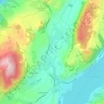
Name: Le Pin topographic map, elevation, terrain.
Average elevation: 584 m
Minimum elevation: 479 m
Maximum elevation: 774 m
Thank you for supporting this site ❤️
Make a donation
Make a donation
Other topographic maps
Click on a map to view its topography, its elevation and its terrain.
Saint-Pierre
France > Auvergne-Rhône-Alpes > Isère > Villages du Lac de Paladru > Paladru
Average elevation: 576 m