
Thank you for supporting this site ❤️
Make a donation
Make a donation
Caineville topographic map
Click on the map to display elevation.
Thank you for supporting this site ❤️
Make a donation
Make a donation
About this map
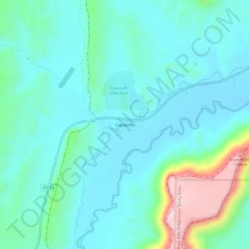
Name: Caineville topographic map, elevation, terrain.
Location: Caineville, Wayne County, Utah, United States (38.31304 -111.03877 38.35304 -110.99877)
Average elevation: 1,465 m
Minimum elevation: 1,391 m
Maximum elevation: 1,771 m
Thank you for supporting this site ❤️
Make a donation
Make a donation
Other topographic maps
Click on a map to view its topography, its elevation and its terrain.
Bicknell
United States > Utah > Wayne County
According to the United States Census Bureau, the town has a total area of 0.62 square miles (1.6 km2), all land. It is situated at an altitude of 7,125 feet (2,172 m) above sea level, in the Rabbit Valley in south-central Utah. The Fremont River flows through the valley, which lies between 11,305-foot (3,446…
Average elevation: 2,180 m
Thank you for supporting this site ❤️
Make a donation
Make a donation