
Town of Hyde Park topographic map
Interactive map
Click on the map to display elevation.
About this map
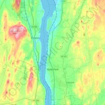
Name: Town of Hyde Park topographic map, elevation, terrain.
Location: Town of Hyde Park, Dutchess County, New York, United States (41.73579 -73.95230 41.87909 -73.85218)
Average elevation: 93 m
Minimum elevation: -8 m
Maximum elevation: 266 m
Other topographic maps
Click on a map to view its topography, its elevation and its terrain.
City of Poughkeepsie
United States > New York > Dutchess County
City of Poughkeepsie, Dutchess County, New York, 12601, United States
Average elevation: 49 m
Hopewell Junction
United States > New York > Dutchess County > Town of East Fishkill
Hopewell Junction, Town of East Fishkill, Dutchess County, New York, United States
Average elevation: 83 m
Rhinecliff
United States > New York > Dutchess County > Town of Rhinebeck
Rhinecliff, Town of Rhinebeck, Dutchess County, New York, 12574, United States
Average elevation: 19 m
Town of La Grange
United States > New York > Dutchess County
Town of La Grange, Dutchess County, New York, 12540, United States
Average elevation: 118 m
Town of Fishkill
United States > New York > Dutchess County
Town of Fishkill, Dutchess County, New York, United States
Average elevation: 178 m
Town of Washington
United States > New York > Dutchess County
Town of Washington, Dutchess County, New York, 12545, United States
Average elevation: 225 m
Village of Millerton
United States > New York > Dutchess County
Village of Millerton, Town of North East, Dutchess County, New York, United States
Average elevation: 243 m
Staatsburg
United States > New York > Dutchess County > Town of Hyde Park
Staatsburg, Town of Hyde Park, Dutchess County, New York, United States
Average elevation: 25 m
Town of North East
United States > New York > Dutchess County
Town of North East, Dutchess County, New York, 12546, United States
Average elevation: 267 m
Town of Pleasant Valley
United States > New York > Dutchess County
Town of Pleasant Valley, Dutchess County, New York, United States
Average elevation: 112 m
Village of Fishkill
United States > New York > Dutchess County
Village of Fishkill, Town of Fishkill, Dutchess County, New York, 12524, United States
Average elevation: 75 m
Glenham
United States > New York > Dutchess County > Town of Fishkill
Glenham, Town of Fishkill, Dutchess County, New York, 12527, United States
Average elevation: 108 m
State Line
United States > New York > Dutchess County > State Line
State Line, Town of North East, Dutchess County, New York, 12546, United States
Average elevation: 268 m
Beacon
United States > New York > Dutchess County > Beacon > Beacon
Beacon, Dutchess County, New York, 12508, United States
Average elevation: 91 m
Town of Red Hook
United States > New York > Dutchess County > Town of Red Hook
Town of Red Hook, Dutchess County, New York, United States
Average elevation: 62 m
Stanfordville
United States > New York > Dutchess County
Stanfordville, Town of Stanford, Dutchess County, New York, 12506, United States
Average elevation: 137 m
Pine Plains CDP
United States > New York > Dutchess County
Pine Plains CDP, Dutchess County, New York, 12567, United States
Average elevation: 149 m
City of Beacon
United States > New York > Dutchess County
City of Beacon, Dutchess County, New York, 12508, United States
Average elevation: 68 m
Hurd Corners
United States > New York > Dutchess County > Town of Pawling
Hurd Corners, Town of Pawling, Dutchess County, New York, 12564, United States
Average elevation: 199 m
Village of Millbrook
United States > New York > Dutchess County
Village of Millbrook, Town of Washington, Dutchess County, New York, 12545, United States
Average elevation: 196 m