
Make a donation
Guangdong Province topographic map
Click on the map to display elevation.
Make a donation
Guangdong Province
Guangdong faces the South China Sea to the south and has a total of 4,300 km (2,700 mi) of coastline. The Leizhou Peninsula is on the southwestern end of the province. There are a few inactive volcanoes on Leizhou Peninsula. The Pearl River Delta is the convergent point of three upstream rivers: the East River, North River, and West River. The river delta is filled with hundreds of small islands. The province is geographically separated from the north by a few mountain ranges collectively called the Nan Mountains (Nan Ling). The highest peak in the province is Shikengkong with an elevation of 6,240 feet (1,900 meters) above sea level.
Make a donation
About this map
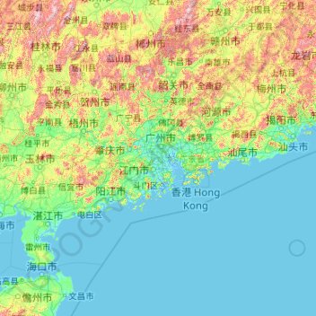
Name: Guangdong Province topographic map, elevation, terrain.
Location: Guangdong Province, China (20.11981 109.38125 25.51952 117.58023)
Average elevation: 194 m
Minimum elevation: -4 m
Maximum elevation: 1,989 m
Make a donation
Other topographic maps
Click on a map to view its topography, its elevation and its terrain.
Make a donation
Mount Everest
China > Tibet > Tingri County
Mount Everest (Nepali: सगरमाथा, romanized: Sagarmāthā; Tibetan: Chomolungma ཇོ་མོ་གླང་མ; Chinese: 珠穆朗玛峰; pinyin: Zhūmùlǎngmǎ Fēng) is Earth's highest mountain above sea level, located in the Mahalangur Himal sub-range of the Himalayas. The China–Nepal…
Average elevation: 7,850 m
Beijing
Beijing is situated at the northern tip of the roughly triangular North China Plain, which opens to the south and east of the city. Mountains to the north, northwest and west shield the city and northern China's agricultural heartland from the encroaching desert steppes. The northwestern part of the…
Average elevation: 47 m
Shiyaling Park
China > Guangdong Province > Longgang District > Buji Sub-district
Average elevation: 63 m
Make a donation