
Thank you for supporting this site ❤️
Make a donation
Make a donation
Lafayette topographic map
Click on the map to display elevation.
Thank you for supporting this site ❤️
Make a donation
Make a donation
About this map
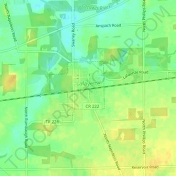
Name: Lafayette topographic map, elevation, terrain.
Location: Lafayette, Allen County, Ohio, 45854, United States (40.75433 -83.95632 40.76262 -83.94526)
Average elevation: 286 m
Minimum elevation: 273 m
Maximum elevation: 297 m
Thank you for supporting this site ❤️
Make a donation
Make a donation
Other topographic maps
Click on a map to view its topography, its elevation and its terrain.
Thank you for supporting this site ❤️
Make a donation
Make a donation
Thank you for supporting this site ❤️
Make a donation
Make a donation
Thank you for supporting this site ❤️
Make a donation
Make a donation