
Make a donation
Lowndes County topographic map
Click on the map to display elevation.
Make a donation
About this map
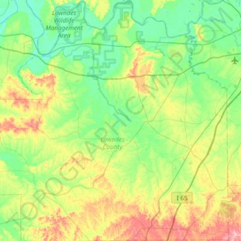
Name: Lowndes County topographic map, elevation, terrain.
Location: Lowndes County, Alabama, United States (31.96170 -86.90840 32.40682 -86.39464)
Average elevation: 75 m
Minimum elevation: 29 m
Maximum elevation: 191 m
Make a donation
Other topographic maps
Click on a map to view its topography, its elevation and its terrain.
Make a donation
Fairhope
United States > Alabama > Baldwin County > Fairhope
According to the U.S. Census Bureau, the city has a total area of 12.0 square miles (31.1 km2), of which 0.019 square mile (0.05 km2), or 0.16%, is water. Its elevation ranges from sea level at the bay to 122 feet (37 m) in the city center.
Average elevation: 35 m
Make a donation
Mentone
United States > Alabama > DeKalb County
Mentone is a town in DeKalb County, Alabama, United States. Mentone, located atop Lookout Mountain, has the highest elevation of any incorporated town in Alabama, and narrowly higher than Hytop.
Average elevation: 470 m
Make a donation
Make a donation
Make a donation
Make a donation
Make a donation
Make a donation
Make a donation
Make a donation
Make a donation
Make a donation
Make a donation
Make a donation
Make a donation
Hawk Pride Mountain
United States > Alabama > Colbert County
Hawk Pride Mountain is a summit in Colbert County, Alabama, in the United States. With an elevation of 820 feet (250 m), is the 489th highest summit in the state of Alabama.
Average elevation: 231 m
Make a donation
Make a donation
Make a donation
Make a donation
Make a donation
Make a donation
Make a donation
Make a donation
Make a donation
Make a donation