
Thank you for supporting this site ❤️
Make a donation
Make a donation
Portishead topographic map
Click on the map to display elevation.
Thank you for supporting this site ❤️
Make a donation
Make a donation
About this map
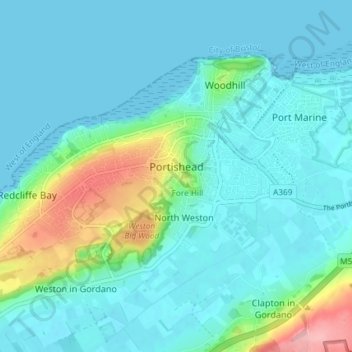
Name: Portishead topographic map, elevation, terrain.
Location: Portishead, North Somerset, England, United Kingdom (51.46364 -2.81890 51.49521 -2.74556)
Average elevation: 24 m
Minimum elevation: 0 m
Maximum elevation: 134 m
Thank you for supporting this site ❤️
Make a donation
Make a donation
Other topographic maps
Click on a map to view its topography, its elevation and its terrain.