
Thank you for supporting this site ❤️
Make a donation
Make a donation
Lamajang topographic map
Click on the map to display elevation.
Thank you for supporting this site ❤️
Make a donation
Make a donation
About this map
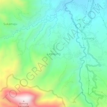
Name: Lamajang topographic map, elevation, terrain.
Location: Lamajang, Bandung, West Java, 40378, Indonesia (-7.14669 107.52299 -7.10669 107.56299)
Average elevation: 1,095 m
Minimum elevation: 830 m
Maximum elevation: 1,731 m
Thank you for supporting this site ❤️
Make a donation
Make a donation
Other topographic maps
Click on a map to view its topography, its elevation and its terrain.