
Make a donation
Bout de la Lande topographic map
Click on the map to display elevation.
Make a donation
About this map
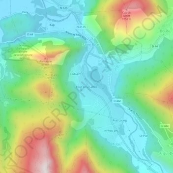
Name: Bout de la Lande topographic map, elevation, terrain.
Average elevation: 754 m
Minimum elevation: 481 m
Maximum elevation: 1,357 m
Make a donation
Other topographic maps
Click on a map to view its topography, its elevation and its terrain.
Saint-Béat
France > Occitanie > Haute-Garonne > Saint-Béat-Lez
La superficie de la commune est de 737 hectares ; son altitude varie de 476 à 1 763 mètres.
Average elevation: 872 m
Lez
France > Occitanie > Haute-Garonne > Saint-Béat-Lez
La superficie de la commune est de 260 hectares. Son altitude minimale, 499 mètres, se situe là où la Garonne quitte la commune pour entrer sur celle de Saint-Béat. L'altitude maximale, 1 180 (ou 1 181) mètres, est atteinte au sud-est, au Rocher du Midi, en limite d'Argut-Dessus, commune associée à Boutx.
Average elevation: 720 m
Saint-Béat
France > Occitanie > Haute-Garonne > Saint-Béat-Lez
La superficie de la commune est de 737 hectares ; son altitude varie de 476 à 1 763 mètres.
Average elevation: 872 m
Make a donation