
Thank you for supporting this site ❤️
Make a donation
Make a donation
Salamanca topographic map
Click on the map to display elevation.
Thank you for supporting this site ❤️
Make a donation
Make a donation
Salamanca
The city is located at an altitude of 800 meters above sea level. The altitude of the municipality varies from 911 meters (Los Montalvos), in the southwest, and 763 meters in the last stretch in the municipality of the Tormes river.
Thank you for supporting this site ❤️
Make a donation
Make a donation
About this map
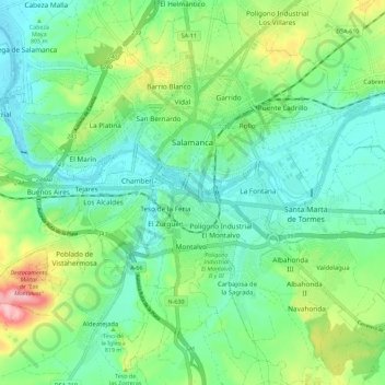
Name: Salamanca topographic map, elevation, terrain.
Location: Salamanca, Castile and León, Spain (40.91463 -5.73580 40.99319 -5.62262)
Average elevation: 812 m
Minimum elevation: 763 m
Maximum elevation: 935 m
Thank you for supporting this site ❤️
Make a donation
Make a donation