
Thank you for supporting this site ❤️
Make a donation
Make a donation
Inn topographic map
Click on the map to display elevation.
Thank you for supporting this site ❤️
Make a donation
Make a donation
About this map
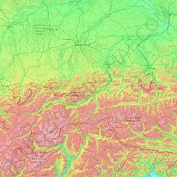
Name: Inn topographic map, elevation, terrain.
Location: Inn, 6500, Austria (46.40649 9.66645 48.57464 13.48480)
Average elevation: 1,152 m
Minimum elevation: 158 m
Maximum elevation: 3,850 m
Thank you for supporting this site ❤️
Make a donation
Make a donation
Other topographic maps
Click on a map to view its topography, its elevation and its terrain.
Thank you for supporting this site ❤️
Make a donation
Make a donation
Königsleiten
Austria > Salzburg > Bezirk Zell am See > Gemeinde Wald im Pinzgau > Königsleiten
Average elevation: 1,703 m