
Thank you for supporting this site ❤️
Make a donation
Make a donation
Tewkesbury topographic map
Click on the map to display elevation.
Thank you for supporting this site ❤️
Make a donation
Make a donation
About this map
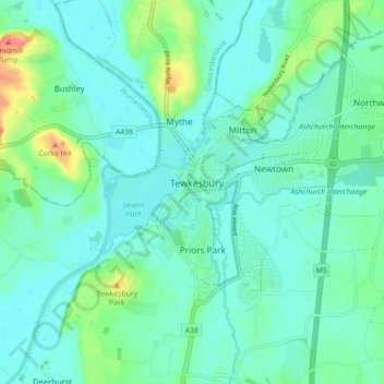
Name: Tewkesbury topographic map, elevation, terrain.
Location: Tewkesbury, Gloucestershire, England, United Kingdom (51.96527 -2.19195 52.01974 -2.12112)
Average elevation: 18 m
Minimum elevation: 6 m
Maximum elevation: 61 m
Thank you for supporting this site ❤️
Make a donation
Make a donation
Other topographic maps
Click on a map to view its topography, its elevation and its terrain.
Weston-sub-Edge
United Kingdom > England > Gloucestershire > Cotswold District
Average elevation: 98 m
Lower Soudley
United Kingdom > England > Gloucestershire > Forest of Dean > Upper Soudley
Average elevation: 119 m
Thank you for supporting this site ❤️
Make a donation
Make a donation