
Make a donation
Highbridge Park topographic map
Click on the map to display elevation.
Make a donation
Highbridge Park
The north and south wings respectively contain the women's and men's locker rooms and are nearly identical. Both have nine windows separated by eight brick pilasters. The stone capitals of the pilasters line up with the lintels of the windows. Ramps lead from the extreme ends of each wing. The ground slopes down northward, so that the northern wing is at a higher elevation above the ground than the southern wing. The eastern facade is similar to the western facade, except that it contains entrances to both genders' respective locker rooms, as well as a bronze clock hanging from the architrave. A cellar is below the northern wing.
Make a donation
About this map
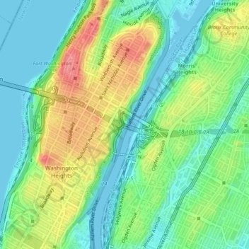
Name: Highbridge Park topographic map, elevation, terrain.
Average elevation: 30 m
Minimum elevation: -3 m
Maximum elevation: 85 m
Make a donation
Other topographic maps
Click on a map to view its topography, its elevation and its terrain.
Morningside Park
United States > New York > New York County > New York
Dutch settlers occupied Manhattan in the early 17th century and called the area around Morningside Park Vredendal, meaning 'peaceful dale'. The lowlands to the east were called Flacken by the Dutch, and were later translated to "Flats" in English. The land to the east was not settled initially because of its…
Average elevation: 20 m
Make a donation
Make a donation
Hunter’s Point South Waterfront Park
United States > New York > New York County > New York
Average elevation: 5 m