
Township of Washington topographic map
Interactive map
Click on the map to display elevation.
About this map
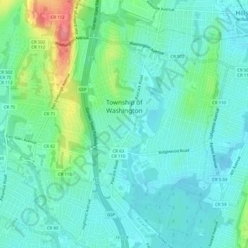
Name: Township of Washington topographic map, elevation, terrain.
Average elevation: 34 m
Minimum elevation: 14 m
Maximum elevation: 96 m
Located within the Pascack Valley of north-central Bergen County, elevations rise gradually in an east to west/south to north trajectory, and range anywhere from 50 feet (15 m) or less in the wooded swamplands behind Westwood Regional High School to approximately 360 feet (110 m) just west of Van Emburgh Avenue. Three hills are in the township: at the border of Westwood, west of Pascack Road, and another located west of Van Emburgh Avenue. Being higher in elevation, it is slightly cooler and less prone to flooding than the rest of the valley and other parts of northwestern Bergen County.
Other topographic maps
Click on a map to view its topography, its elevation and its terrain.
Ridgewood
United States > New Jersey > Bergen County
Ridgewood, Bergen County, New Jersey, United States
Average elevation: 51 m
Northvale
United States > New Jersey > Bergen County
Northvale, Bergen County, New Jersey, 07647, United States
Average elevation: 19 m
Bergenfield
United States > New Jersey > Bergen County
Bergenfield, Bergen County, New Jersey, 07621, United States
Average elevation: 30 m
Palisades Park
United States > New Jersey > Bergen County
Palisades Park, Bergen County, New Jersey, 07650, United States
Average elevation: 35 m
Rutherford
United States > New Jersey > Bergen County
Rutherford, Bergen County, New Jersey, 07070, United States
Average elevation: 13 m
Fort Lee
United States > New Jersey > Bergen County
Fort Lee, Bergen County, New Jersey, 07024, United States
Average elevation: 45 m
Fair Lawn
United States > New Jersey > Bergen County
Fair Lawn, Bergen County, New Jersey, 07410, United States
Average elevation: 25 m
Hasbrouck Heights
United States > New Jersey > Bergen County
Hasbrouck Heights, Bergen County, New Jersey, 07604, United States
Average elevation: 24 m
Saddle River
United States > New Jersey > Bergen County
Saddle River, Bergen County, New Jersey, United States
Average elevation: 84 m
Saddle Brook
United States > New Jersey > Bergen County
Saddle Brook, Bergen County, New Jersey, United States
Average elevation: 18 m
Garfield
United States > New Jersey > Bergen County
Garfield, Bergen County, New Jersey, 07026, United States
Average elevation: 16 m
Park Ridge
United States > New Jersey > Bergen County
Park Ridge, Bergen County, New Jersey, 07656, United States
Average elevation: 67 m
Ramsey
United States > New Jersey > Bergen County
Ramsey, Bergen County, New Jersey, 07446, United States
Average elevation: 117 m
Hillsdale
United States > New Jersey > Bergen County
Hillsdale, Bergen County, New Jersey, 07642, United States
Average elevation: 36 m
Emerson
United States > New Jersey > Bergen County
Emerson, Bergen County, New Jersey, 07630, United States
Average elevation: 21 m
New Bridge
United States > New Jersey > Bergen County > New Milford
New Bridge, New Milford, Bergen County, New Jersey, 07661, United States
Average elevation: 19 m
Harrington Park
United States > New Jersey > Bergen County
Harrington Park, Bergen County, New Jersey, 07640, United States
Average elevation: 15 m
Franklin Lakes
United States > New Jersey > Bergen County
Franklin Lakes, Bergen County, New Jersey, 07417, United States
Average elevation: 130 m
Wyckoff
United States > New Jersey > Bergen County
Wyckoff, Bergen County, New Jersey, 07481, United States
Average elevation: 118 m
Oakland
United States > New Jersey > Bergen County
Oakland, Bergen County, New Jersey, 07436, United States
Average elevation: 133 m
Upper Saddle River
United States > New Jersey > Bergen County
Upper Saddle River, Bergen County, New Jersey, 07458, United States
Average elevation: 112 m
Ridgefield Park
United States > New Jersey > Bergen County
Ridgefield Park, Bergen County, New Jersey, 07660, United States
Average elevation: 9 m
Montvale
United States > New Jersey > Bergen County
Montvale, Bergen County, New Jersey, 07645, United States
Average elevation: 78 m
Fairview
United States > New Jersey > Bergen County
Fairview, Bergen County, New Jersey, 07022, United States
Average elevation: 46 m
Teterboro
United States > New Jersey > Bergen County > Teterboro
Teterboro, Bergen County, New Jersey, 07608, United States
Average elevation: 12 m
Teaneck Township
United States > New Jersey > Bergen County
Teaneck Township, Bergen County, New Jersey, 07666, United States
Average elevation: 20 m
Cliffside Park
United States > New Jersey > Bergen County
Cliffside Park, Bergen County, New Jersey, 07010, United States
Average elevation: 46 m
Dumont
United States > New Jersey > Bergen County
Dumont, Bergen County, New Jersey, 07628, United States
Average elevation: 26 m
Alpine
United States > New Jersey > Bergen County
Alpine, Bergen County, New Jersey, 07620, United States
Average elevation: 48 m
Closter
United States > New Jersey > Bergen County
Closter, Bergen County, New Jersey, 07624, United States
Average elevation: 32 m
Westwood
United States > New Jersey > Bergen County
Westwood, Bergen County, New Jersey, United States
Average elevation: 23 m
Ramapo Valley County Reservation
United States > New Jersey > Bergen County > Ringwood
Ramapo Valley County Reservation, Ringwood, Mahwah, Bergen County, New Jersey, United States
Average elevation: 178 m
Oradell
United States > New Jersey > Bergen County
Oradell, Bergen County, New Jersey, 07649, United States
Average elevation: 20 m
New Milford
United States > New Jersey > Bergen County
New Milford, Bergen County, New Jersey, 07646, United States
Average elevation: 19 m
Englewood
United States > New Jersey > Bergen County
Englewood, Bergen County, New Jersey, 07361, United States
Average elevation: 46 m
Warren Point
United States > New Jersey > Bergen County > Fair Lawn
Warren Point, Fair Lawn, Bergen County, New Jersey, 07410, United States
Average elevation: 22 m
Edgewater
United States > New Jersey > Bergen County
Edgewater, Bergen County, New Jersey, 07020, United States
Average elevation: 33 m
Allendale
United States > New Jersey > Bergen County
Allendale, Bergen County, New Jersey, 07401, United States
Average elevation: 94 m
Little Ferry
United States > New Jersey > Bergen County
Little Ferry, Bergen County, New Jersey, 07643, United States
Average elevation: 4 m
Carlstadt
United States > New Jersey > Bergen County > Carlstadt
Carlstadt, Bergen County, New Jersey, 07072, United States
Average elevation: 13 m
River Edge
United States > New Jersey > Bergen County
River Edge, Bergen County, New Jersey, 07661, United States
Average elevation: 17 m
Bogota
United States > New Jersey > Bergen County > Bogota
Bogota, Bergen County, New Jersey, 07603, United States
Average elevation: 19 m
Waldwick
United States > New Jersey > Bergen County
Waldwick, Bergen County, New Jersey, 07463, United States
Average elevation: 75 m
Westwood
United States > New Jersey > Bergen County > Westwood > Westwood
Westwood, Bergen County, New Jersey, 07630, United States
Average elevation: 31 m
Ho-Ho-Kus
United States > New Jersey > Bergen County
Ho-Ho-Kus, Bergen County, New Jersey, United States
Average elevation: 58 m
Lodi
United States > New Jersey > Bergen County > Lodi
Lodi, Bergen County, New Jersey, 07644, United States
Average elevation: 19 m
Moonachie
United States > New Jersey > Bergen County
Moonachie, Bergen County, New Jersey, 07074, United States
Average elevation: 5 m
Hillsdale
United States > New Jersey > Bergen County > Hillsdale > Hillsdale
Hillsdale, Bergen County, New Jersey, 07642, United States
Average elevation: 40 m
Rochelle Park
United States > New Jersey > Bergen County > Rochelle Park
Rochelle Park, Bergen County, New Jersey, 07662, United States
Average elevation: 19 m
Glen Rock
United States > New Jersey > Bergen County > Glen Rock > Glen Rock
Glen Rock, Bergen County, New Jersey, 07452, United States
Average elevation: 52 m