
99425 topographic map
Interactive map
Click on the map to display elevation.
About this map
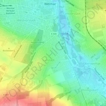
Name: 99425 topographic map, elevation, terrain.
Location: 99425, Südstadt, Weimar, Thüringen, Deutschland (50.96850 11.33079 50.96860 11.33089)
Average elevation: 250 m
Minimum elevation: 211 m
Maximum elevation: 324 m
Other topographic maps
Click on a map to view its topography, its elevation and its terrain.
Weimar
Deutschland > Thüringen > Weimar > Weimar
Weimar, Thüringen, 99423, Deutschland
Average elevation: 282 m
99427
Deutschland > Thüringen > Weimar
99427, Weimar Nord, Weimar, Thüringen, Deutschland
Average elevation: 311 m
Schloss Tiefurt
Deutschland > Thüringen > Weimar > Tiefurt
Schloss Tiefurt, 14, Hauptstraße, Tiefurt, Weimar, Thüringen, 99425, Deutschland
Average elevation: 231 m
Ilmpark
Deutschland > Thüringen > Weimar
Ilmpark, Parkvorstadt, Weimar, Thüringen, 99425, Deutschland
Average elevation: 243 m