
Thank you for supporting this site ❤️
Make a donation
Make a donation
Ellis Park topographic map
Click on the map to display elevation.
Thank you for supporting this site ❤️
Make a donation
Make a donation
Ellis Park
Adelaide is a planned city, and the Adelaide Park Lands are an integral part of Colonel William Light's 1837 plan. Light chose a site spanning the River Torrens (known as Yatala by the Kaurna people), and planned the city to fit the topography of the landscape, "on rising ground".
Thank you for supporting this site ❤️
Make a donation
Make a donation
About this map
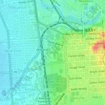
Name: Ellis Park topographic map, elevation, terrain.
Average elevation: 33 m
Minimum elevation: 16 m
Maximum elevation: 77 m
Thank you for supporting this site ❤️
Make a donation
Make a donation