
Make a donation
Pindus topographic map
Click on the map to display elevation.
Make a donation
Pindus
The Pindus (also Pindos or Pindhos; Greek: Πίνδος, romanized: Píndos; Albanian: Pindet; Aromanian: Pindu) is a mountain range located in Northern Greece and Southern Albania. It is roughly 160 km (100 miles) long, with a maximum elevation of 2,637 metres (8652') (Mount Smolikas). Because it runs along the border of Thessaly and Epirus, the Pindus range is known colloquially as the spine of Greece. The mountain range stretches from near the Greek-Albanian border in southern Albania, entering the Epirus and Macedonia regions in northern Greece down to the north of the Peloponnese. Geologically, it is an extension of the Dinaric Alps, which dominate the western region of the Balkan Peninsula.
Make a donation
About this map
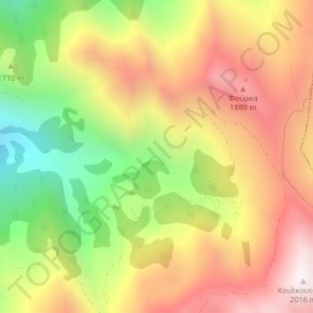
Name: Pindus topographic map, elevation, terrain.
Average elevation: 1,510 m
Minimum elevation: 942 m
Maximum elevation: 2,013 m
Make a donation
Other topographic maps
Click on a map to view its topography, its elevation and its terrain.
Δήμος Καρδίτσας
Greece > Thessaly and Central Greece > Karditsa Regional Unit
Average elevation: 473 m