
Thank you for supporting this site ❤️
Make a donation
Make a donation
South Beloit topographic map
Click on the map to display elevation.
Thank you for supporting this site ❤️
Make a donation
Make a donation
About this map
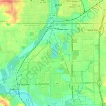
Name: South Beloit topographic map, elevation, terrain.
Average elevation: 236 m
Minimum elevation: 217 m
Maximum elevation: 265 m
Thank you for supporting this site ❤️
Make a donation
Make a donation
Other topographic maps
Click on a map to view its topography, its elevation and its terrain.
Rock Cut State Park
United States > Illinois > Winnebago County > Machesney Park
Average elevation: 265 m
Thank you for supporting this site ❤️
Make a donation
Make a donation