
Thank you for supporting this site ❤️
Make a donation
Make a donation
Mission Hills topographic map
Click on the map to display elevation.
Thank you for supporting this site ❤️
Make a donation
Make a donation
About this map
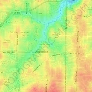
Name: Mission Hills topographic map, elevation, terrain.
Location: Mission Hills, Johnson County, Kansas, United States (39.00054 -94.63044 39.03386 -94.60748)
Average elevation: 288 m
Minimum elevation: 257 m
Maximum elevation: 308 m
Thank you for supporting this site ❤️
Make a donation
Make a donation
Other topographic maps
Click on a map to view its topography, its elevation and its terrain.