
Thank you for supporting this site ❤️
Make a donation
Make a donation
Maras Tengah topographic map
Click on the map to display elevation.
Thank you for supporting this site ❤️
Make a donation
Make a donation
About this map
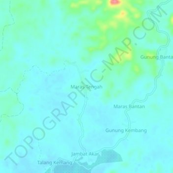
Name: Maras Tengah topographic map, elevation, terrain.
Location: Maras Tengah, Seluma, Bengkulu, Sumatra, Indonesia (-4.32621 102.79914 -4.28621 102.83914)
Average elevation: 20 m
Minimum elevation: 6 m
Maximum elevation: 99 m
Thank you for supporting this site ❤️
Make a donation
Make a donation
Other topographic maps
Click on a map to view its topography, its elevation and its terrain.