
Thank you for supporting this site ❤️
Make a donation
Make a donation
Kabanjahe topographic map
Click on the map to display elevation.
Thank you for supporting this site ❤️
Make a donation
Make a donation
About this map
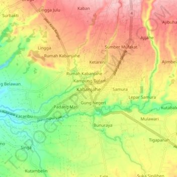
Name: Kabanjahe topographic map, elevation, terrain.
Location: Kabanjahe, Karo, North Sumatra, Sumatra, 22111, Indonesia (3.06091 98.44912 3.14091 98.52912)
Average elevation: 1,194 m
Minimum elevation: 1,092 m
Maximum elevation: 1,294 m
Thank you for supporting this site ❤️
Make a donation
Make a donation
Other topographic maps
Click on a map to view its topography, its elevation and its terrain.