
Thank you for supporting this site ❤️
Make a donation
Make a donation
Sungai Pua topographic map
Click on the map to display elevation.
Thank you for supporting this site ❤️
Make a donation
Make a donation
About this map
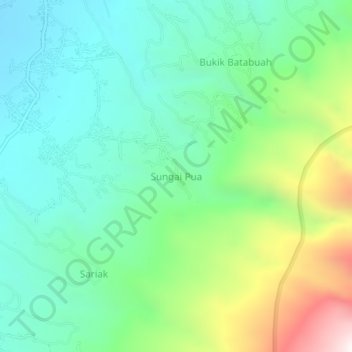
Name: Sungai Pua topographic map, elevation, terrain.
Location: Sungai Pua, Agam, West Sumatra, Sumatra, Indonesia (-0.38400 100.40653 -0.34400 100.44653)
Average elevation: 1,403 m
Minimum elevation: 1,053 m
Maximum elevation: 2,273 m
Thank you for supporting this site ❤️
Make a donation
Make a donation
Other topographic maps
Click on a map to view its topography, its elevation and its terrain.