
Earthaven Ecovillage topographic map
Interactive map
Click on the map to display elevation.
About this map
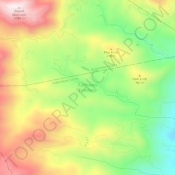
Name: Earthaven Ecovillage topographic map, elevation, terrain.
Average elevation: 693 m
Minimum elevation: 376 m
Maximum elevation: 1,043 m
Other topographic maps
Click on a map to view its topography, its elevation and its terrain.
Whitehouse
United States > North Carolina > Rutherford County
Whitehouse, Rutherford County, North Carolina, United States
Average elevation: 378 m
Henrietta
United States > North Carolina > Rutherford County
Henrietta, Rutherford County, North Carolina, 28076, United States
Average elevation: 250 m
Cedar Knob
United States > North Carolina > Rutherford County
Cedar Knob, Rutherford County, North Carolina, 28720, United States
Average elevation: 845 m
Forest City
United States > North Carolina > Rutherford County
Forest City, Rutherford County, North Carolina, 28043, United States
Average elevation: 285 m
Spindale
United States > North Carolina > Rutherford County
Spindale, Rutherford County, North Carolina, 28160, United States
Average elevation: 305 m
Lake Lure
United States > North Carolina > Rutherford County
Lake Lure, Rutherford County, North Carolina, 28746, United States
Average elevation: 363 m
James F. Crowe Memorial Park
United States > North Carolina > Rutherford County > Forest City > River Hills
James F. Crowe Memorial Park, River Hills, Forest City, Rutherford County, North Carolina, United States
Average elevation: 274 m
Rutherfordton
United States > North Carolina > Rutherford County
Rutherfordton, Rutherford County, North Carolina, United States
Average elevation: 302 m
Bostic
United States > North Carolina > Rutherford County > Bostic > Bostic
Bostic, Rutherford County, North Carolina, United States
Average elevation: 276 m
Bostic
United States > North Carolina > Rutherford County
Bostic, Rutherford County, North Carolina, United States
Average elevation: 275 m
Sandy Mush
United States > North Carolina > Rutherford County > Sandy Mush
Sandy Mush, Rutherford County, North Carolina, 28043, United States
Average elevation: 273 m
Rutherfordton
United States > North Carolina > Rutherford County > Rutherfordton
Rutherfordton, Rutherford County, North Carolina, 28139, United States
Average elevation: 300 m
Corinth
United States > North Carolina > Rutherford County > Corinth
Corinth, Rutherford County, North Carolina, 28040, United States
Average elevation: 299 m
Westminster
United States > North Carolina > Rutherford County > Westminster
Westminster, Rutherford County, North Carolina, United States
Average elevation: 288 m
Lake Lure
United States > North Carolina > Rutherford County > Lake Lure
Lake Lure, Rutherford County, North Carolina, United States
Average elevation: 375 m
Sunshine
United States > North Carolina > Rutherford County > Sunshine
Sunshine, Rutherford County, North Carolina, 28018, United States
Average elevation: 344 m
Union Mills
United States > North Carolina > Rutherford County
Union Mills, Rutherford County, North Carolina, 28167, United States
Average elevation: 326 m
Chimney Rock
United States > North Carolina > Rutherford County > Chimney Rock
Chimney Rock, Rutherford County, North Carolina, 28720, United States
Average elevation: 550 m
Deerfield
United States > North Carolina > Rutherford County > Lake Lure > Deerfield
Deerfield, Lake Lure, Rutherford County, North Carolina, 28746, United States
Average elevation: 502 m
Ellenboro
United States > North Carolina > Rutherford County
Ellenboro, Rutherford County, North Carolina, United States
Average elevation: 302 m