
Make a donation
Lianyungang topographic map
Click on the map to display elevation.
Make a donation
Lianyungang
Lianyungang City, where Huaguoshan Scenic Area is located, is located in the middle of China's thousands of miles of maritime territory, in the northeast of Jiangsu Province, bordering the Yellow Sea to the east, the Central Plains to the west, Qilu to the north, Jianghuai to the south, and facing Japan and the Korean Peninsula across the sea. The scenic area covers an area of 75.39 square kilometers and has 136 peaks. Among them, the Yunu Peak of Huaguo Mountain is the highest peak in Jiangsu Province, with an altitude of 624.4 meters and majestic cliffs.
Make a donation
About this map
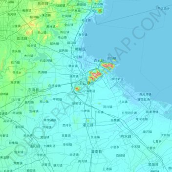
Name: Lianyungang topographic map, elevation, terrain.
Location: Lianyungang, Jiangsu, China (33.98548 118.39555 35.14704 119.93028)
Average elevation: 17 m
Minimum elevation: -3 m
Maximum elevation: 563 m
Make a donation
Other topographic maps
Click on a map to view its topography, its elevation and its terrain.
Nanjing
There are mainly two types of soil in Nanjing: zonal soil and cultivated soil. The zonal soil is yellow-brown soil in the northern and central areas of Nanjing, and red soil in the southern part of the border with Anhui. The cultivated soil formed by man-made farming is mainly paddy soil, and there are some…
Average elevation: 25 m
Make a donation