
Brahmaputra topographic map
Interactive map
Click on the map to display elevation.
About this map
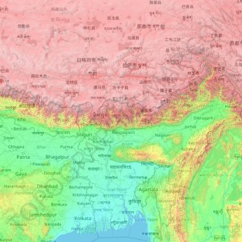
Name: Brahmaputra topographic map, elevation, terrain.
Location: Brahmaputra, China (23.79180 82.31781 30.43782 95.44212)
Average elevation: 2,296 m
Minimum elevation: -2 m
Maximum elevation: 8,096 m
Other topographic maps
Click on a map to view its topography, its elevation and its terrain.
Beijing
Beijing is situated at the northern tip of the roughly triangular North China Plain, which opens to the south and east of the city. Mountains to the north, northwest and west shield the city and northern China's agricultural heartland from the encroaching desert steppes. The northwestern part of the…
Average elevation: 47 m
Shiyaling Park
China > Guangdong Province > Longgang District > Buji Sub-district
Average elevation: 63 m
Mount Everest
China > Tibet > Tingri County
Mount Everest (Nepali: सगरमाथा, romanized: Sagarmāthā; Tibetan: Chomolungma ཇོ་མོ་གླང་མ; Chinese: 珠穆朗玛峰; pinyin: Zhūmùlǎngmǎ Fēng) is Earth's highest mountain above sea level, located in the Mahalangur Himal sub-range of the Himalayas. The China–Nepal…
Average elevation: 7,850 m