
Ada topographic map
Click on the map to display elevation.
About this map
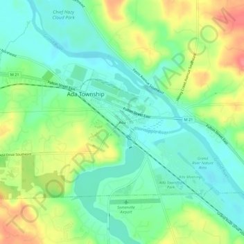
Name: Ada topographic map, elevation, terrain.
Average elevation: 208 m
Minimum elevation: 181 m
Maximum elevation: 256 m
Other topographic maps
Click on a map to view its topography, its elevation and its terrain.
Grand Rapids
United States > Michigan > Kent County
Grand Rapids is situated in a region characterized by relatively flat terrain that gently undulates, influenced by the glacial activity that shaped much of the Midwest. The city itself sits at an elevation of approximately 640 feet (195 meters) above sea level, with the surrounding landscape showcasing low…
Average elevation: 216 m
Echo Lake
United States > Michigan > Kent County > Grand Rapids Charter Township
Average elevation: 240 m
Grand Rapids
United States > Michigan > Kent County
Grand Rapids developed on the banks of the Grand River, where there was once a set of rapids, at an altitude of 610 feet (186 m) above sea level. Ships could navigate on the river up to this fall line, stopping because of the rapids. The river valley is flat and narrow, surrounded by steep hills and bluffs.…
Average elevation: 216 m
Comstock Park
United States > Michigan > Kent County > Plainfield Charter Township
Average elevation: 206 m