
Thank you for supporting this site ❤️
Make a donation
Make a donation
Washington Parish topographic map
Click on the map to display elevation.
Thank you for supporting this site ❤️
Make a donation
Make a donation
About this map
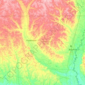
Name: Washington Parish topographic map, elevation, terrain.
Location: Washington Parish, Louisiana, United States (30.66275 -90.34736 31.00490 -89.72657)
Average elevation: 60 m
Minimum elevation: 8 m
Maximum elevation: 124 m
Thank you for supporting this site ❤️
Make a donation
Make a donation
Other topographic maps
Click on a map to view its topography, its elevation and its terrain.
Thank you for supporting this site ❤️
Make a donation
Make a donation
Thank you for supporting this site ❤️
Make a donation
Make a donation
Black Pearl
United States > Louisiana > Orleans Parish > New Orleans > Black Pearl
Black Pearl is located at 29°56′11″N 90°08′02″W / 29.93639°N 90.13389°W / 29.93639; -90.13389 and has an elevation of 8 feet (2.4 m). According to the United States Census Bureau, the district has a total area of 0.49 square miles (1.3 km2). 0.26 square miles (0.67 km2) of which is land…
Average elevation: 3 m