
Thank you for supporting this site ❤️
Make a donation
Make a donation
Mencilla topographic map
Click on the map to display elevation.
Thank you for supporting this site ❤️
Make a donation
Make a donation
About this map
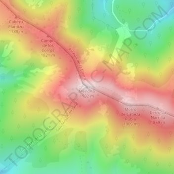
Name: Mencilla topographic map, elevation, terrain.
Location: Mencilla, San Millán de Lara, Burgos, Castilla y León, España (42.18586 -3.31233 42.18596 -3.31223)
Average elevation: 1,642 m
Minimum elevation: 1,344 m
Maximum elevation: 1,927 m
Thank you for supporting this site ❤️
Make a donation
Make a donation
Other topographic maps
Click on a map to view its topography, its elevation and its terrain.