
Thank you for supporting this site ❤️
Make a donation
Make a donation
Libmanan topographic map
Click on the map to display elevation.
Thank you for supporting this site ❤️
Make a donation
Make a donation
About this map
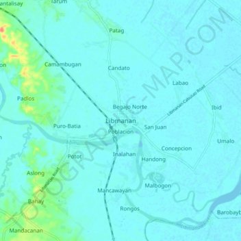
Name: Libmanan topographic map, elevation, terrain.
Location: Libmanan, Camarines Sur, Bicol Region, 4407, Philippines (13.65604 123.02121 13.73604 123.10121)
Average elevation: 6 m
Minimum elevation: -1 m
Maximum elevation: 51 m
Thank you for supporting this site ❤️
Make a donation
Make a donation
Other topographic maps
Click on a map to view its topography, its elevation and its terrain.
Nabua
Nabua has about 8,803.0600 hectares or 99.42% very low elevation or less than 100 meters elevation and remaining 51.3593 hectares or 0.58% of low elevation or between 100 and 300 meters elevation. Its slope covers about 7,927.3616 hectares or 89.53% which are level to nearly level (0-3%) while the remaining…
Average elevation: 27 m
Thank you for supporting this site ❤️
Make a donation
Make a donation