
Thank you for supporting this site ❤️
Make a donation
Make a donation
Kahuman topographic map
Click on the map to display elevation.
Thank you for supporting this site ❤️
Make a donation
Make a donation
About this map
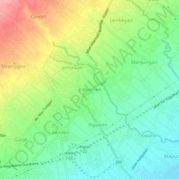
Name: Kahuman topographic map, elevation, terrain.
Location: Kahuman, Klaten, Central Java, Java, 57475, Indonesia (-7.68025 110.57525 -7.64025 110.61525)
Average elevation: 236 m
Minimum elevation: 186 m
Maximum elevation: 317 m
Thank you for supporting this site ❤️
Make a donation
Make a donation
Other topographic maps
Click on a map to view its topography, its elevation and its terrain.