
Thank you for supporting this site ❤️
Make a donation
Make a donation
Santa Ana topographic map
Click on the map to display elevation.
Thank you for supporting this site ❤️
Make a donation
Make a donation
Santa Ana
The highest elevation in the town is the Santa Ana volcano (which measures 2365 meters).
Thank you for supporting this site ❤️
Make a donation
Make a donation
About this map
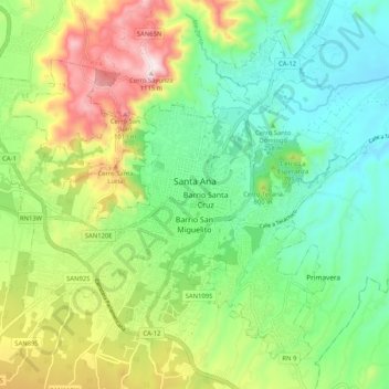
Name: Santa Ana topographic map, elevation, terrain.
Average elevation: 712 m
Minimum elevation: 510 m
Maximum elevation: 1,096 m
Thank you for supporting this site ❤️
Make a donation
Make a donation