
Thank you for supporting this site ❤️
Make a donation
Make a donation
Tesson topographic map
Click on the map to display elevation.
Thank you for supporting this site ❤️
Make a donation
Make a donation
About this map
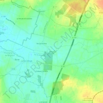
Name: Tesson topographic map, elevation, terrain.
Average elevation: 40 m
Minimum elevation: 26 m
Maximum elevation: 62 m
Thank you for supporting this site ❤️
Make a donation
Make a donation
Other topographic maps
Click on a map to view its topography, its elevation and its terrain.
Saint-Étienne-la-Cigogne
France > Nouvelle-Aquitaine > Deux-Sèvres > Plaine-d'Argenson
Average elevation: 55 m